Identifying and Locating Trees of Framework Species Using Photography from an Unmanned Aerial Vehicle (UAV)
FORRU Contributors
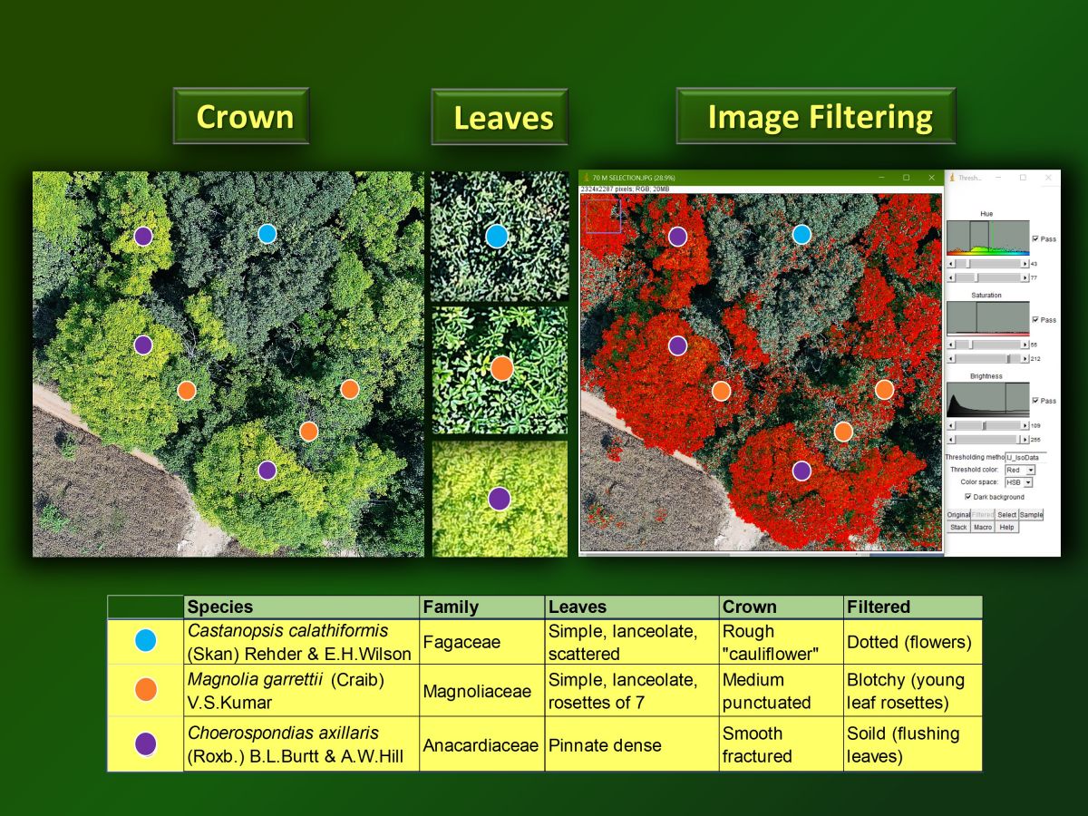
ABSTRACT: The need to locate and identify potential seed trees has become crucial, if we are to meet ambitious global reforestation targets of UN New York Declaration on Forests, 2014, which aims to restore forest in 350 million ha of degraded land by the year 2030. Tree-species identification in tropical forests is hindered by low visibility from the ground. The possibility of viewing trees from above, using remote sensing platforms (planes and satellites) and imaging technologies such as hyperspectral imagery and lidar are being investigated. However, such technologies are very expensive and not readily accessible. In contrast, unmanned aerial vehicles (UAVs), with high-resolution cameras, have become a lot more affordable in recent years. Therefore, the research presented here determined if an off-the-shelf UAV could be used to easily identify nine (9) target tree species in dense regenerating forest from above. The study site was above Ban Mae Sa Mai (BMSM), Doi Suthep-Pui National Park, Northern Thailand, where forest had been restored in two plots (0.0064 km2 each), by planting framework tree species 20 years previously, by Chiang Mai University’s Forest Restoration Research Unit (FORRU-CMU). Digital aerial photographs (20 megapixels) of tree crowns of nine framework tree species (Artocarpus gomezianus Wall. Ex Trecul, Castanoposis calathiformis (Skan) Rehder & E.H. Wilson, Castanopsis tribuloides (Sm.) A.DC., Choerospondias axillaris (Roxb.) B.L. Burtt & A.W. Hill, Ficus altissima Blume, Magnolia garrettii (Craib)V.S. Kumar, Pinus kesiya Royle ex Gordon, Prunus cerasoides Buch, Ham.ex D. Don, Toona ciliata M. Roem) were taken monthly over 8 months, using a DJI Phantom 4 Pro, flown at 50 m above the ground, along a identical autonomous flight plans, using Litchi flight planning software. The photographs were used to develop visual species-identification keys, based on crown and leaf characteristics and image filtering. The keys were then tested for reliability in another similarly aged validation plot, using independent volunteer observers. Identification accuracy exceeded 50% for seven of nine target species and 70% for four of the species. Although, the system cannot be relied upon to locate all trees of target species, it is useful for locating enough seed trees to initiate forest restoration projects.